How I made a Flag about a Flooded World
So a company by the name of Flagmaker-Print lets you make your own flags, and print them so your designs can be shared across the internet, and you can print your flags with any custom designs. Recently, they held a discord competition to design a flag of a nation set in a world where sea levels have risen tremendous amounts. Whomever wins this competition gets that flag delivered to them for FREE!
The competition didn't specify the exact sea levels we had to use, so I tried to look for some maps for ideas. I eventually found a website called floodmap.net that lets you change the sea level of the entire world to see how much would be under water.
For example, if all the icebergs, glaciers, and ice in the world melted into the sea, (extreme product of climate change) the world's sea levels would rise by about 80 meters:
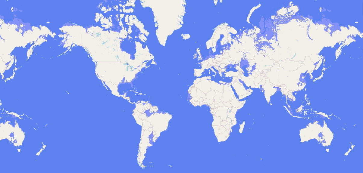
Now the floodmap isn't always the most accurate, so I wouldn't recommend using it for a professional paper.
Now, I changed the sea level to different levels until I found one that had cool looking shapes. 220.

Now this is way past the realism factor, so I made the story of a stray ice comet falling into the Pacific ocean to account for the 140 meters of water levels not on planet Earth.
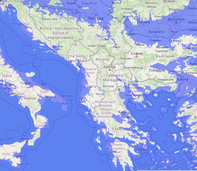
Now there are many places here that one could pick for a new nation. In India, where I hail from, most of the coastal areas and parts connecting India to Pakistan and Nepal is gone. Which makes this a perfect island of India to work with.
There's also Greece, who was always a bunch of islands, ever expanding southwards, but now they have a chance to expand northward with the cutoff of the two major powers in the Balkans. Those powers are Hungary and Romania (both currently underwater). There are also many slavic populations in these regions, so the 1990s have called again for another try at Yugoslavia?
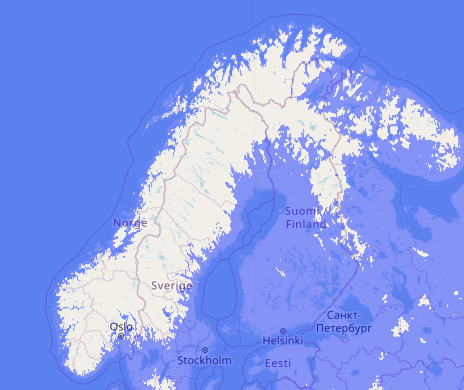
If we go farther north, we can see that Denmark and southern Sweden have fallen to the tides, but the region around Oslo (the capital of Norway), still stands. Most of the industrial south of Norway is still here, so the Nordics can arise possibly back to the naval power of the Vikings!
Korea, Vladivostok, and Sakhalin (currently all islands in the picture below), were once belonging to the Japanese Empire. If the Japanese wanted to, they could use their great naval power to regain control of the former territories, and form a better federation.
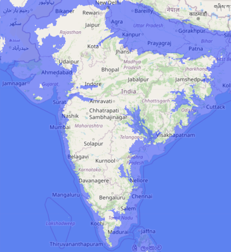

Now while all these are good and nice, I had my eyes set on another region... the American Midwest! (probably the only time anyone's been excited for Michigan)
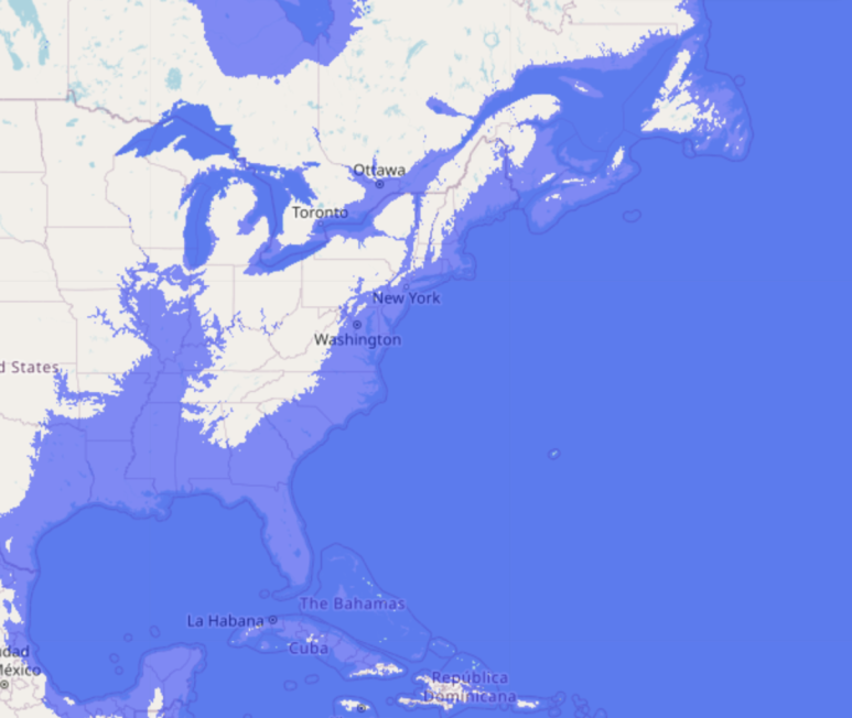
I had an idea for an eastern federation of islands separate from the western states of America, so I started to clean up this image. I used Gimp to clear the parts that were underwater, so that there would be a big blue background. Then I colored in the places that I wanted this nation to have.
Now since this is a federation, we need provinces (states for you Americans) to be present. So I did some digging around for interesting new names for the regions of eastern America.
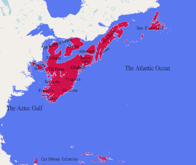
Some of them have more creative names as you can see. These are the meanings of each name, as follows:
Dearborn Islands - Chicago is close to a fort called Fort Dearborn, which is why the people in suburban Chicago call the area Dearborn. Since that area has now become a small archipelago, I thought it be fitting for the Dearborn name to live on.
Till Plains - Both Indiana and Ohio don't have many similarities, other than they are both on a slightly higher plateau than the rest of the east coast. This plateau is called the Till plains because of its rich amount of soil. I decided to combine these both into one state for my sake, because theres not much to either state other than the plains.
Alleghany - Alleghany is a county with the largest amount of Amish people in Pennsylvania. This group of people is mainly present in western Pennsylvania and Maryland, so it seemed like a better name than "The Amish State".
Hudson Valley - Hudson Valley is a name for the portion of New York State that borders both Lake Erie and the Atlantic Ocean.
Adirondacks - This region is just a really big mountain in the upper reaches of New York. It looked like the best name for it, since nothing else happens in upper New York.
Virginia and Carolina - Virginia is the combination of West Virginia and regular Virginia, while Carolina = North Carolina + South Carolina.
Kentucky - Still has the original restraunt of Kentucky's Fried Chicken. The colonel will be remembered.
Franklin - In the early days of the Articles of Confederation, North Carolina used to own much of eastern Tennessee. At first they gave it to the federal govt to pay off war debts, but then took it back to use the Appalachians for resources to pay off debt (smart thinking!). Settlers were growing in the region and didn't like the Carolinian pressure, and staged a revolt with the name Franklin after the great Revolutionary War hero, Benjamin Franklin.
Dixie - After the Civil war, there was a split in the Democrat party, with northern Democrats allying with republicans to support African American rights, and desegregationist legislature. The southern Democrats were called Dixie-crats because of them being below the Mason-Dixie Line (the line used to decide which states are free/slave states before the Civil War).
There are also the Caribbean Colonies which is expected at this point. I mean, its an American State, of course we're going to exploit other countries!
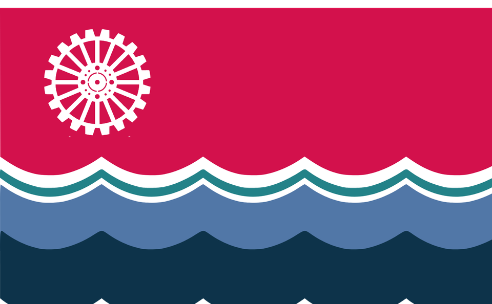
I decided to name this nation the Rust Belt Commonwealth, after the Steel belt from Illinois to Jersey. There's also a lot more salt water, so the name got rusted a little bit.
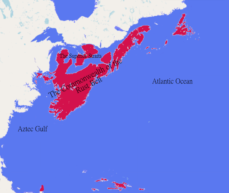
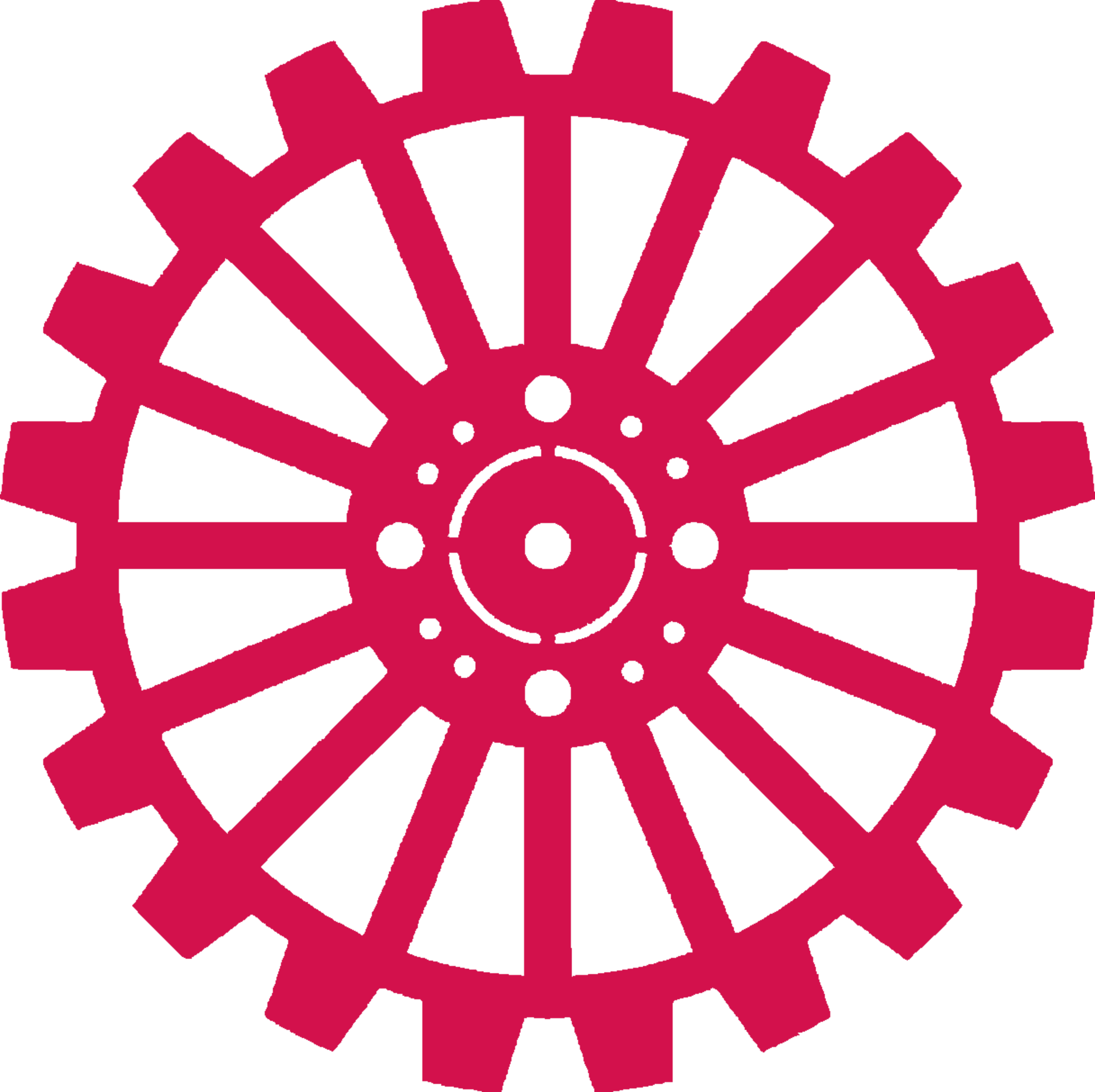
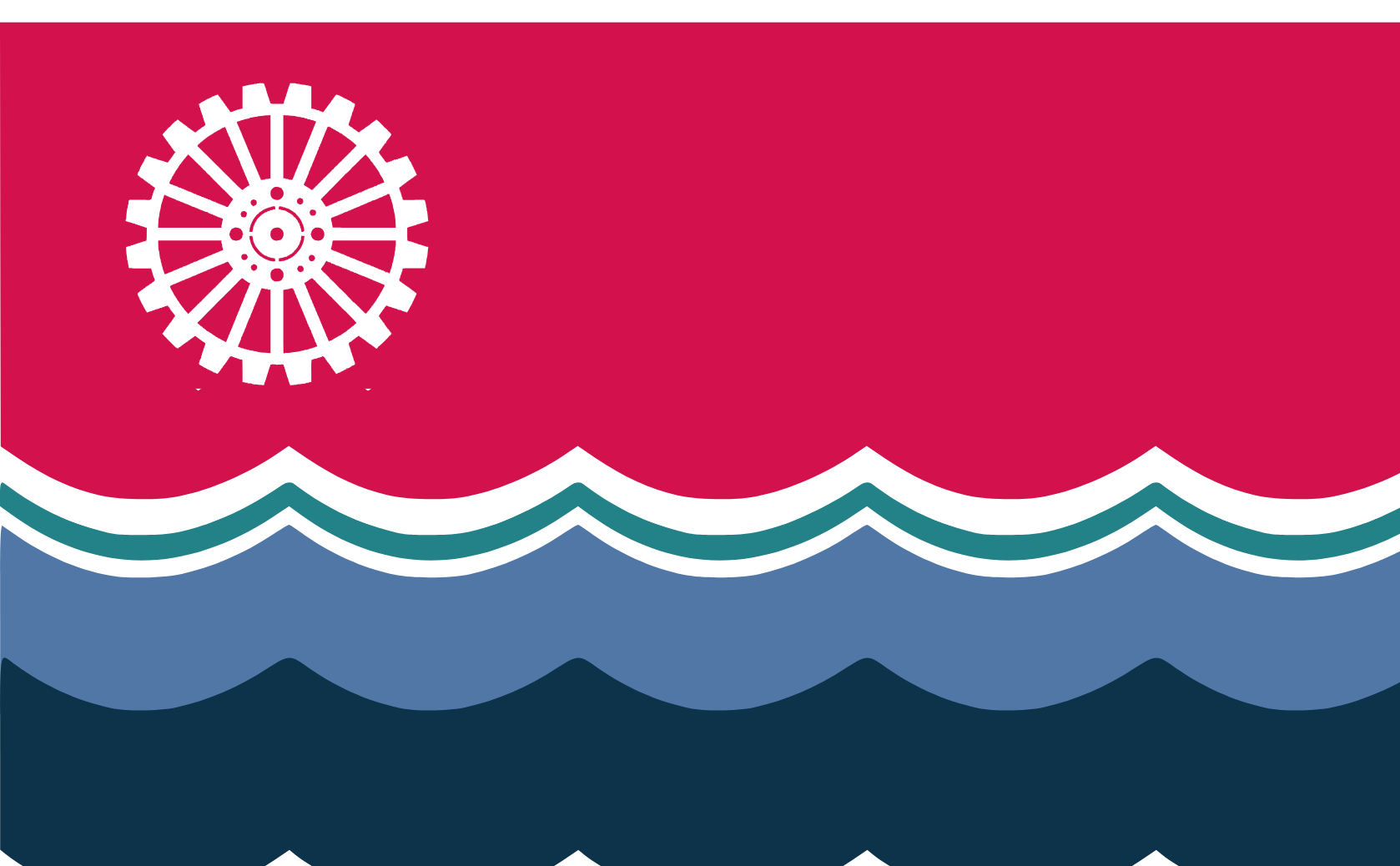
Now came the problem of the flag. Because it was surrounded by three different water bodies (The Gulf of Mexico, Atlantic Ocean, and the –now connected– Great Lakes), I grabbed pictures of each and used the colors from each for different sets of waves on the flag. The Teal, light, and dark blues are the "Superior Straits", The Atlantic Ocean, and the "Aztec Gulf". I chose the gear for the industry of this nation, with the steel belt from Illinois to Jersey, the Oil companies along the Appalachians, and the southern farming industries in Franklin, Carolina, and Dixie. The Burgundy-esque color is just my favorite color.
Now if you want to start your own world building of a floodmap, I would recommend doing it like this. Just know that you will have to do a lot of research to get meaningful names and symbols. Make sure to visit Flagmaker-Print to check out the next competition and get prepared. If you would like to comment under this article, please consider becoming a member! It doesn't cost any money, just your will to state opinions!